Lotmark turns parcel, hazard, terrain, building, and environmental data into structured, source-cited features — built for the AI products being built in proptech, insurance, and mortgage today.
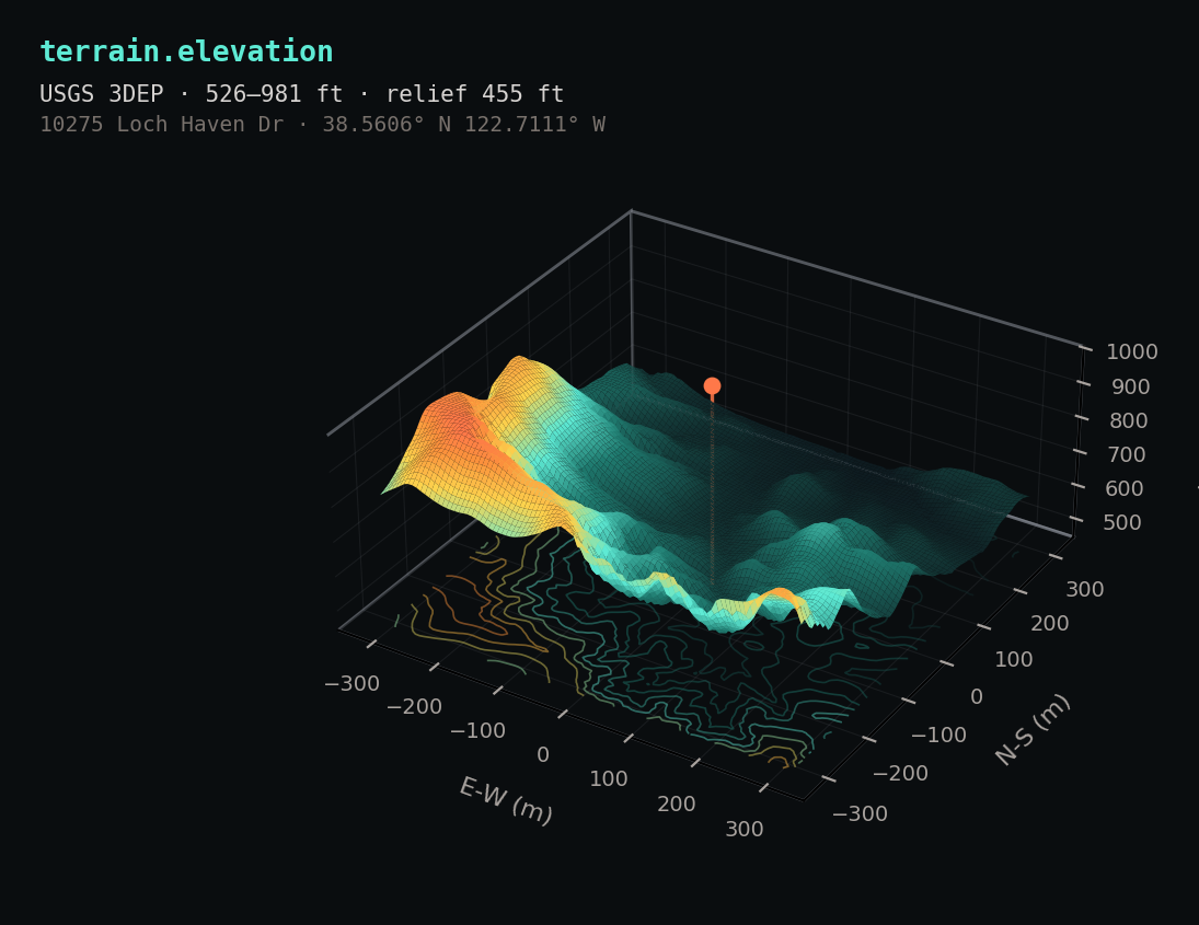
{ "parcel_id": "lm_06097_049-130-022", "freshness_days": 4, "risk_features": { "fire": { "whp_class": 4, "whp_class_label": "high", "fhsz_zone": "very_high", "distance_to_burn_perimeter_m": 1840, "last_burn_year_within_5km": 2017, "source": { "agency": "USFS Wildfire Hazard Potential", "as_of": "2023-08-01" }, "confidence": 0.94 }, "flood": { "fema_zone": "X", "in_sfha": false, "source": { "agency": "FEMA NFHL", "panel_id": "06097C0735F" } } }, "narrative": { "text": "This 0.42-acre parcel sits in CAL FIRE's 'very high' Fire Hazard Severity Zone with WHP class 4...", "grounded_in": ["risk.fire", "risk.flood", "terrain"] }, "embedding": { "dim": 1536, "model": "text-embedding-3-small" } }
Every field carries a source object with agency, product, and date. Narratives ship with a grounded_in array so your RAG pipeline can verify them. Embeddings included.
Twelve government data sources, normalized to a single parcel schema, enriched with LLM narratives and embeddings, and exposed through one API. Each step is auditable; each output is cited.
County assessor records, USGS 3DEP LIDAR, FEMA NFHL, USFS WHP, CAL FIRE FHSZ, USDA SSURGO, NREL, NLCD, building footprints.
Geospatial joins, zonal stats, distance features, slope/elevation derivation, LLM-generated narratives, 1536-dim embeddings, quality gates.
REST endpoints. Tool-call-shaped JSON. Bulk download for Growth tier. Webhook refresh signals. Source provenance on every field.
Every datapoint ships with the agency, product version, and as-of date that produced it. Your RAG pipeline can verify claims. Your underwriters can defend them.
Distance to burn perimeter, WHP class, FHSZ zone, slope, canopy, soil — composable inputs your model can reason over. No black-box 1-10 number you can't audit.
Structured JSON, pre-generated narratives, included embeddings. Drop into your agent's tool definitions in minutes — not weeks of feature engineering.
Surface fire, flood, and roof signals at quote-time. Catch hazard mismatches before the binder issues.
Climate-exposed properties surface their risks at application, not at appraisal. Fewer surprises late in close.
Give your agent factual property data with citations instead of hallucinations from training data.
Slope, soil, flood, hazard, and distance features for development, solar siting, and portfolio risk.
Lotmark launches with four states where wildfire, flood, and wind exposure are reshaping property economics — and where the data is publicly available and rigorously source-able.
Priced by successful parcel enrichment, not generic API calls. Every included unit returns structured features, citations, narratives, and embeddings.
For testing the API shape before production.
Start DeveloperFor solo founders and AI prototypes.
Start BuilderFor production apps and small teams.
Start StartupFor scaling teams in proptech, insurance, mortgage.
Start GrowthEnterprise starts at $3k-$10k+/mo for annual contracts, redistribution rights, SLAs, and custom coverage. Talk to us about Enterprise.
Lotmark is built by Mitchell Marfinetz, an applied ML researcher with 3.5+ years shipping production infrastructure for DeFi protocols. Two arXiv papers on optimization and learned optimizers (2510.21647, 2512.11853), a $225K Arbitrum Foundation grant on prior work, and a strong opinion that data quality is the moat AI infrastructure deserves.
Built and maintained by one person who actually uses it. Public methodology. Open dataset cards. No data brokers, no resold feeds — every layer assembled, normalized, and source-cited end-to-end.
Lotmark is a Marfinetz Labs product.
Get a sample API key for Sonoma County. We'll send a real response, the schema, and a walkthrough slot if you ask for one.